
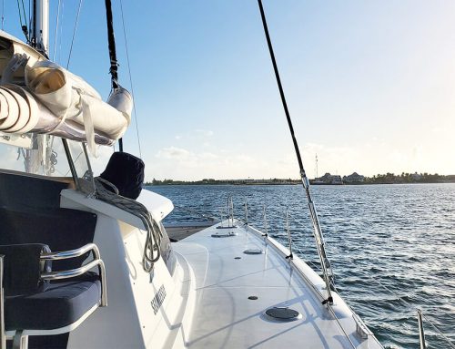
Last time we checked in, we were about to sail The Whale and were a bit nervous about entering and exiting our very first cut. Thankfully we made it, and the last 2 weeks aboard Seamlessly have been the most-pleasant so far. Day by day, we’re getting more and more comfortable navigating, raising and dropping sails, picking out safe anchorages and getting close-ish to other vessels without totally panicking that we’re going to hit something. We’re nowhere near comfortable to take our catamaran into a busy anchorage like the one inside Marsh Harbour… but we’re getting there.
We were quite nervous and psyched out by the Whale, but it turned out to be a not-so-scary part of our first 2 weeks sailing. After leaving Noname Cay, passing through the Whale Cut, we ended up by Great Guana Cay, before heading down to Man-O-War Cay, Marsh Harbour, Treasure Cay, looping back down to Marsh Harbour to drop off Leanne’s sister; Christina, stopping by Water and Archer Cay on our way.
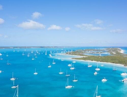
Great Guana Cay
Before leaving the safety of Green Turtle Cay, we we spent an evening planning our next anchorage. There’s so much that goes into anchorage planning – what will the wind be doing when we get there? How will it change overnight? What’s the sea state like? How will the tide influence the depth over time? Can we reach land for the puppies? After much research, we decided that our first stop past The Whale would be Great Guana Cay, because it provided protection from Easterly winds, and we could anchor right outside of Baker’s Bay (26.690017, -77.161483) – which had glowing reviews in our Bahamas Cruising Guide.
After spending a night at the anchorage ensuring that our anchor wasn’t going to drag, we hopped in the dinghy for a day at Baker’s Bay only to learn that the facilities and everything inside the bay are for members only. So, we took our dinghy down to Guana Harbour, about 2 nm North, and found a seemingly abandoned dock to tie up on (26.668009, -77.117386). A short 20-minute stroll yielded us some plantains and a few other groceries. We stopped by the BTC on our way to see if we could finally get a SIM card for our phones, but they recommended we go to Marsh Harbour for the activation of new SIM cards.
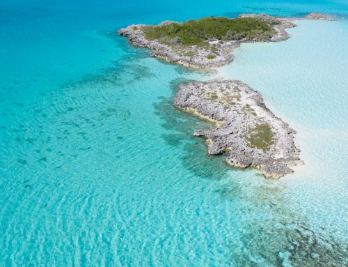
Great Guana Cay was nice, but we really enjoyed Spoil Cay (26.684771, -77.173659); a very small uninhabited island across from Baker’s Bay with lots of beach for our dog Coconut to run on, loads of sea shells to collect, and an awesome place to fly the drone.

Our dinghy anchored at Spoil Cay. It was our first time landing the dinghy on a leeshore (meaning, the wind was pushing the dinghy ashore quite violently). We got REALLY wet in our attempt, but figured it out.

Coconut, our doberman, found and delivered a coconut to us – so proud. Now, to teach her how to retrieve FRESH ones. It’ll happen.

A floatplane flew by while we were at Spoil Cay. Leanne is obsessed with them, so a picture of Tropic Ocean Airways was a must.
Man-O-War Cay

Our trek down to Man-O-War Cay was the very first time we sailed, alone, without a guest onboard. It was very peaceful and relaxing sail, averaging 6 to 8 knots in 8 to 11 knot winds. It was a strange feeling, getting to make decisions on our own, becoming more intuitive with the process. We still have so much to learn, but felt good to have just enough skill to make this sail feel good.
Another first – leaving the boat for an entire day. Yup, we did it! After anchoring at the South Man-O-War anchorage, we slept a little, woke up at the crack of dawn, jumped in the dinghy and zoomed into Man-O-War Harbour to take Albury’s Ferry into Marsh Harbour. We arrived an hour early just so we could figure out the dinghy dock situation; we were pretty nervous about leaving the dinghy all day, but found a great little place at the Man-O-War ferry dock (26.593866, -77.005415), tied up the stern and bow and used some steel cable to lock it to a piling.
We went into Marsh Harbour for food from Maxwell’s Supermarket, alcohol from 700 Wines & Spirits, and project odds and ends from Standard Hardware. We were pleasantly surprised by the variety of choices in each of the stores. The alcohol and hardware costs were about the same as in the US, but the food was about 30 to 40% more. We’ll do a provisioning in the Bahamas post here soon, as Leanne loves to talk about food, buying food, and saving money on food. So, watch for that.
Also, beginners tip? It’s a horrible idea to take the ferry into town, provision, and do everything by foot. Take a cab. Your back will thank you. Better yet, don’t take the ferry to provision. If you’re brave (we’re not there yet) anchor in Marsh Harbour, take your dinghy into the Union Jack Public Dock, walk to the stores, take a cab back, and be done with it. Way easier, and in the end, less costly. The ferry ride isn’t cheap!
But, we were happy we took the ferry, stretching our limits and learning that everything we think is a big deal, really isn’t. When we got back to the dock in the afternoon, our dinghy was still there (yay!), the engine started (double yay!), and Seamlessly was right where we left her.
Marsh Harbour
The wind shifted on us a day after we got back from our ferry adventure, so we decided to anchored out by Mermaid Reef (26.555583, -77.056333) outside of Marsh Harbour even though all of the reviews said the holding was horrible. Our anchor, a Rocna 50, had no issues keeping us in place.
We took the dinghy to the reef and tied up at one of the mooring balls, and it was worth it. There were plenty of fish and we even saw a turtle!

Marsh Harbour is a popular spot to provision and catch up with neighbors. The harbour looks easy enough to get into, and we could, but chose not to because being that close to boats makes us nervous and also, we don’t love being close to people lol.

We really enjoyed swimming with the fish at Mermaid Reef, it was well worth the stop and we returned a couple of days later to do it all over again.
Treasure Cay

Now, for the best part of this week’s adventures – Christina, Leanne’s little sister came aboard! We’re learning that it’s a bit of a shuffle getting people on and off the boat. Sure, if we were in a marina, meeting up with people would be easy. But when you’re anchoring and wind can shift, and ferry’s can be late, and you can’t take the dinghy out past sunset or before sunrise, things get a little complicated. But, Christina got onboard after a 20+ hour journey from Canada and we planned a 15nm sail up to Treasure Cay to anchor out by the marina entrance (26.657567, -77.284517).
Treasure Cay is a bit of land on Great Abaco Island, a traveler favorite for this area. Seeing as we hadn’t been around other humans in over a month, we decided to take the dinghy in, rent a golf cart, and enjoy a nice lunch at Treasure Sands Club (they’re $14 cocktails are worth every penny) together. It was a beautiful day that we’ll never forget.

Our dinghy tied up at the dinghy dock in Treasure Cay… beside another Canadian dinghy. We really need a sticker like they have. Yay, Canada!

Water Cay (and Archer Cay)

After having an amazing time in Treasure Cay we sailed South to Water Cay (26.608467, -77.1757). We couldn’t find much information about Water Cay or Archer Cay, and with only a couple of days with Christina, we really wanted it to be a good spot. Thankfully, this is now our favorite anchorage so far. We’ll let our pictures tell the rest of the story.


Hurricane Season
Each day since we’ve left Florida has zoomed by, if we aren’t researching out next anchorage or looking at weather, we work on things like planning for hurricane season which starts in June and lasts until November. I can't believe we're even thinking about June now, but it is really just around the corner. We're under the impression that a lot of different insurance companies use the same hurricane zone with their policies, but we weren't able to find anything online - where is the tropic of cancer, where can you sail during hurricane season and still have coverage? So many questions with very little answers online. So, we created this hurricane no-go zone map showing the area where our insurance company will not cover our boat against hurricane damage during hurricane season. We're thinking it may be helpful for you, too.
I love this so much! Curious as to what you do for hurricane season too. We are all over the place.